A new analysis from Greenpeace USA finds that the California National Marine Sanctuaries under review by the Trump administration overlap with geologic basins containing significant oil and gas deposits.
Summary Findings
- Expansions of National Marine Sanctuaries (NMS) off the California coast ordered by Presidents Bush and Obama are currently under review by the Trump administration.
- A geospatial analysis has found that three of these California NMS regions overlap with offshore geologic basins estimated to contain significant resources of oil and gas.
- Three NMS areas that are under threat are the Greater Farallones, Cordell Bank, and Monterey Bay NMS. Together these three areas form a contiguous block of protected ocean running for much of Central California’s coastline.
- The overlap between the expansion regions of two of these NMS and the assessed geologic basins (excluding state waters) is 351,017 acres — an area nearly the size of Sequoia National Park.
- The two basins that overlap with the expanded NMS regions currently under review contain 3.41 billion barrels of oil and 3.62 trillion cubic feet of natural gas. It is unknown how much of those resources would be found in the overlap regions.
Interactive Map
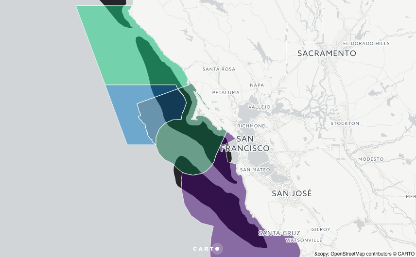
An interactive map of oil and gas assessment basins and protected marine sanctuaries is available online at greenpeace.carto.com and is embedded below.
The map shows the overlap between offshore geologic basins and NMS regions. Geologic basins (shown in black) are from north to south: Point Arena, Bodega, Año Nuevo, Santa Maria-Partington. National Marine Sanctuaries under review include Farallones (green), Cordell Bank (blue), and Monterey Bay (purple), with the original areas shaded darker and the expansion areas shaded lighter. Move the cursor over each region to display its name and (for geologic basins) the estimated oil and gas reserves contained in that basin.
Trump’s Offshore Review
As a result of President Trump’s Executive Order 13795 the Department of Commerce is reviewing all designations and expansions of National Marine Sanctuaries and Marine National Monuments since April 28, 2007. A Public comments on this review were accepted earlier this summer. This review is running in parallel to a similar review of National Monuments being conducted by the Department of the Interior.
Commerce is requesting comment on 5 Marine National Monuments and six NMS — four of which are found off the California coast. The review notes that the original designations of the NMS “are not subject to this review, rather only their respective expansion areas completed in the past 10 years.”
Trump’s Executive Order explicitly calls for analysis of the “opportunity costs associated with potential energy and mineral exploration and production from the Outer Continental Shelf (OCS), in addition to any impacts on production in the adjacent region.” A region’s status as a National Marine Sanctuary is directly relevant to offshore oil drilling because sanctuaries are typically withdrawn from oil and gas leasing. As such, stripping a region of NMS status could be a prelude to opening that area up to future oil and gas leases.
In addition to Farallones, Cordell Bank and Monterey Bay, a fourth California sanctuary — Channel Islands NMS — is also under review. Channel Islands NMS was expanded in May 2007 when the National Oceanic and Atmospheric Administration (NOAA) established several Marine Reserves and one Marine Conservation Area largely within the federal waters of the existing Sanctuary. Given the comparatively smaller sizes of these expanded areas and their more complicated management structure, we do not include an overlap analysis with oil and gas resources for the Channel Islands NMS in this report.
National Assessment of Oil and Gas
The Bureau of Ocean Energy Management (BOEM) conducts periodic National Assessments of U.S. offshore oil and gas resources. The most recent assessment of the Pacific OCS was in 2016.
The three NMS considered here overlap with four geologic basins assessed by BOEM: Point Arena, Bodega, Año Nuevo and Santa Maria-Partington, which together form the Central California Province. For each basin, BOEM estimates the Undiscovered Technically Recoverable Resources (UTRR) and the Undiscovered Economically Recoverable Resources (UERR) expected to be contained there. Note that these are not technically oil or gas reserves since they are (as yet) undiscovered, and are instead classified as resources.
BOEM’s estimates of UTRR for the four basins are as follows (see Table 1):
- Point Arena Basin: 2.01 billion bbl of oil (Bbbl), 2.10 trillion cubic feet (Tcf) of natural gas
- Bodega Basin: 1.40 Bbbl and 1.52 Tcf
- Año Nuevo Basin: 0.71 Bbbl and 0.75 Tcf
- Santa Maria-Partington Basin: 1.11 Bbbl and 0.84 Tcf
- Totals for the Central California Province: 5.23 Bbbl of oil and 5.21 Tcf of natural gas.
Over half of these resources are estimated to be economically recoverable even at low to mid-range prices for oil and gas, and should oil and gas prices rise in the future, a significant fraction would be considered economic to extract. BOEM considers three price scenarios (see Table 6):
- For a low-price scenario consisting of $40/bbl oil and $2.14/Mcf natural gas, the Central California province could see the production of 2.78 Bbbl of oil and 2.81 Tcf of natural gas.
- For a mid-price scenario consisting of $100/bbl oil and $5.34/Mcf natural gas, the the Central California province could see the production of 3.97 Bbbl of oil and 3.96 Tcf of natural gas.
- For a high-price scenario consisting of $160/bbl oil and $8.54/Mcf natural gas, the the Central California province could see the production of 4.30 Bbbl of oil and 4.27 Tcf of natural gas.
Geospatial Analysis
Conducting an overlap analysis of geographic regions provided by NOAA and BOEM, we find that significant portions of the Greater Farallones and Cordell Bank NMS expansion regions overlap with the assessed geologic basins.
After excluding state waters (extending 3 nautical miles from shore) from the areas considered for the geologic basins, we find the following:
- 23% (298,831 acres) of the expanded region of Farallones NMS overlaps with two offshore basins (the Point Arena and Bodega basins).
- 11% (52,186 acres) of the expanded region of Cordell Bank NMS overlaps with the Bodega Basin.
- The expanded region of Monterey Bay NMS (which consists of the Davidson Seamount) does not overlap with any geologic basin in BOEM’s assessment.
- Considering all expanded NMS regions, the overlap totals to 351,017 acres.
- As noted above, the two basins that overlap with the expanded NMS regions contain 3.41 Bbbl of oil and 3.62 Tcf of natural gas.
Although not under threat from the Trump administration’s current review, the original designation areas for these NMS also show significant overlap with oil and gas bearing geologic basins:
- 43% (348,503 acres) of the original Gulf of the Farallones NMS overlaps with the Bodega and Año Nuevo basins
- 47% (160,651 acres) of the original Cordell Bank NMS overlaps with the Bodega Basin.
- 39% (1,326,990 acres) of the original Monterey Bay NMS overlaps with the Bodega, Año Nuevo and Santa Maria-Partington basins.
- Considering all original NMS regions, the overlap totals to 1,836,144 acres.
It is important to note that we do not have detailed information about how much of the assessed quantities of oil and gas might be found in any given overlap region, merely the size of the spatial overlap.
The geospatial analysis was conducted using Google Earth Engine. Current NMS shapefiles were obtained from NOAA, and original designation (pre-expansion) shapefiles were obtained from a 2006 archived version of the same NOAA webpage. Geologic basin shapefiles were obtained from BOEM, and the state-federal waters boundary was obtained from USGS.
Is California Drilling Likely to Happen?
California’s governor, both senators, as well as numerous federal, state and local officials, and coastal communities are lined up in opposition to new drilling. And given that even the oil industry sounds lukewarm on the idea, it is worth asking whether new drilling off California’s coast is likely to occur.
Trump has made no secret of his desire to greatly expand fossil fuel extraction, both onshore and off, and has issued numerous Executive Orders and reviews seeking to open up access to areas that were previously off limits. Interior Secretary Ryan Zinke has taken the first steps to re-initiate the Five-Year Plan governing offshore oil drilling, and requested public comment on which areas should be considered for expanded oil and gas leasing.
In the past, oil companies such as ConocoPhillips, Noble, Statoil, and California’s own Chevron have expressed interest in drilling in the Pacific OCS. In August 2017, a coalition of industry groups called on BOEM “to make new areas in the Atlantic, Eastern Gulf of Mexico, Beaufort and Chukchi Seas of Alaska, and the Pacific available for leasing.”
DOI official Katherine MacGregor recently raised the possibility of Pacific drilling in a Congressional hearing, stating: “The secretary [Zinke] has had quite a few questions about California, and other areas that seem to come up every time you talk about a five-year plan.”
Even if Trump’s review leaves California’s NMS areas unchanged, oil and gas leasing could still occur in the federal waters outside of those regions. Secretary Zinke could include the Pacific OCS region in the Proposed Program for the new Five-year plan, and then schedule lease sales sometime between 2019 and 2024. Industry interest might be low for right now, but that could change quickly if oil prices rise in the future.
For Further Information
This analysis is published by Greenpeace USA. Analysis contributed by Tim Donaghy. For media inquiries please contact Cassady Craighill ([email protected]). September 2017.