Southeast Asia Transboundary Haze 2019
This year, the plummeting air quality in Southeast Asia, caused by forest fires in parts of Indonesia and the Mekong Sub-Region, has raised questions on the effectiveness of an ASEAN agreement to prevent haze pollution.
The ASEAN Agreement on Transboundary Haze Pollution is a legally binding environmental agreement applied to all 10 ASEAN member states, signed in 2002, to reduce haze pollution mainly through monitoring and prevention activities. Indonesia was the last country that ratified the ASEAN Agreement on Transboundary Haze Pollution (AATHP) and submitted the ratification document to the ASEAN Secretariat in January 2015.
There are several reasons why the AATHP has failed. Among them is the lack of an efficient process by the ASEAN Centre whose purpose is to facilitate cooperation and coordination among parties in managing the impact of land and/or forest fires, from which haze pollution arises. However, the ASEAN Centre shall work on the basis that the national authority will act first to put out the fires. When the national authority declares an emergency situation, it may make a request to the ASEAN Centre to provide assistance. So the ASEAN Centre is unable to act on its own accord, and may only be an effective tool in giving support to a member state.
As of today, we have seen that both the Agreement and the Roadmap failed to prevent forest fires from taking place and haze crossing borders between ASEAN state members.
Transboundary Haze Pollution in the Mekong Sub-Region
The Greater Mekong Sub-Region is also cloaked in a smoky haze from the seasonal burning of crops during the dry season, with industrial maize production largely blamed here. There is an increasing demand for maize to process into animal feed in the region and maize production has come under the spotlight for causing deforestation with the burning of land for pre and post harvest– this all contributes to regional air pollution.
Agricultural land in the Mekong Sub-Region is significantly devoted to industrial-scale mono-cropping. The main commercial boom crops are rubber, sugarcane, oil palm, cassava and maize. 76 percent of concession areas across the region are agricultural, although cassava and maize predominantly cultivated under contract farming arrangements.[1] Yet information about agribusiness occupying the land is often lacking at multiple levels. Without this information, the government cannot hold corporations accountable for the health and environmental impacts originating from where land or forest fires take place, eventually causing haze pollution. Accountability is the key area upon which the ASEAN leaders should focus.
Greenpeace Thailand 2019 analysis[2] derived from the Moderate Resolution Imaging Spectroradiometer (MODIS) on NASA’s Terra and Aqua satellites showed that more than 583,459.2 hectares (3,646,620 rai) of land in the Upper Northern Thailand, and 1,203,928 hectares (7,524,550 rai) of land in Shan State of Myanmar belong to maize plantations. Combining the land cover and hotspot data :
- In 2019, the highest density of burn scar and hotspot in both Upper Northern Thailand (15,828.8 Hectares(98,930 rai) / 3,992 fire hotspot) and Shan State of Myanmar (21,936 Hactares(137,100 rai)/ 8,209 hotspot) were recorded during April.
- Between December 2018 to May 2019, there were a total of 6,879 fire hotspots within maize plantations of Upper Northern Thailand.
- Between December 2018 to May 2019, there were a total of 14,828 fire hotspots within maize plantations of Shan State of Myanmar
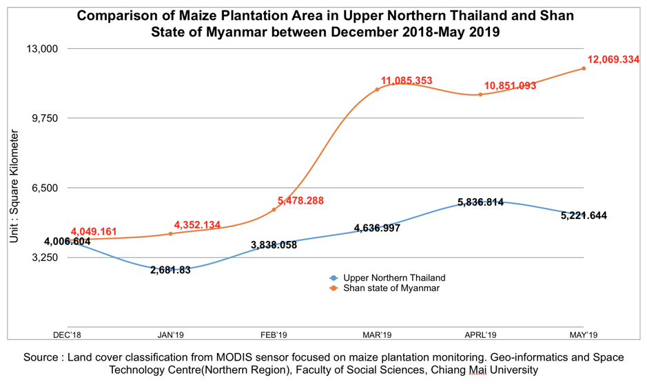
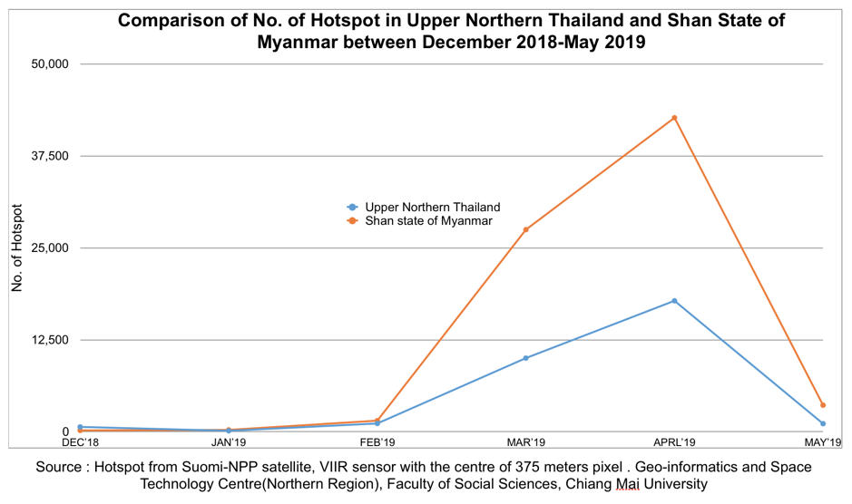
These data represent the areas of maize plantation (first graph) and the rising numbers of hotspots (second graph) during cultivation in preparation for the next growing season in Shan State of Myanmar and Upper Northern Thailand between December 2018-May 2019
From this research, the area of maize plantations in Shan State of Myanmar has increased alarmingly within only six months (from 400,660 hactares or 4,006.6 square kilometers in December 2018 to 1,206,933 hactares or 12,069.33 square kilometer in May 2019). However, there is no publicly available information on who occupies/uses the land, and specifically how land or forest fires originate.
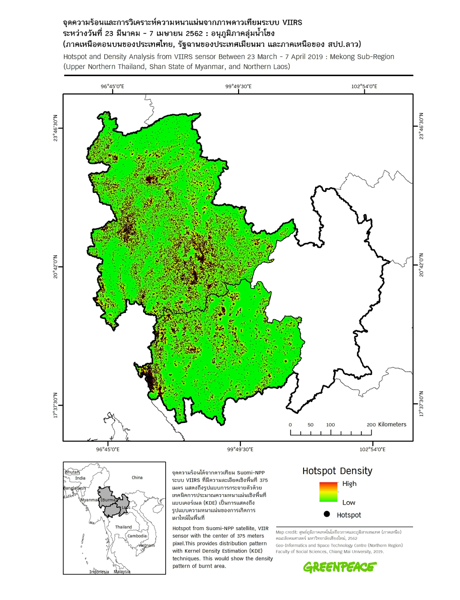

Left: The density of hotspots in Upper Northern Thailand and Shan State of Myanmar, April 2019. hotspot represents fire detections from Suomi-NPP satellite, VIIRS sensor.
Right: The density of burn scars in Upper Northern Thailand and Shan State of Myanmar, April 2019. Burn scar areas are calculated from Burn Scar Index (dNBR) with near infrared and shortwave infrared from MODIS sensor. The raster grid cell size is approximately 250 meters.
In 2015[3], Geo-Informatics and Space Technology Development Agency (GISTDA) has reported number of the hotspots and burnt areas caused by maize and other commercial crops within different land covers, including forest areas and the national forest reserve areas in 10 provinces of Northern Thailand. However, the data is not made available for public use after 2015.
While it should not necessarily be seen as the sole cause of national and transboundary haze, a study of agricultural value chains, such as that involving maize production, highlights a significant contributing factor. Agribusiness conglomerates are expanding their reach around the region, looking not only to a high demand for maize as animal feed in Thailand and China, but also towards the emergence of new domestic markets in Myanmar and Lao PDR. Agricultural investment policy facilitates this trend, with environmental regulation unable to keep up. If we are to promote sustainable practices in the emergence of mono-cropping, that can help alleviate transboundary haze, then farmers must be provided with improved land tenure security, contracts with corporations, and technical support.
Transboundary haze pollution should be prevented and monitored both domestically at source, as well as internationally through mutual cooperation.
Accountability is the key area upon which ASEAN leaders should focus. ASEAN governments must develop its taskforce and enforce the law against those responsible for forest fires and transboundary haze into The Roadmap on Asean Cooperation Towards Transboundary Haze Pollution Control.
[1] Ingalls, M.L., Diepart,J,-C., Truong, N. Hayward, D., Neil, T., Phomphakdy, C., Bernhard, R., Fogarizzu, S., Epprecht, M., Nanhthavong, V., Vo, DH., Nguyen, D., Nguyen, P.A., Saphangthong, T., Inthavong, C., Hett, C. and Tagliarino, N.2018. State of Land in the Mekong Region. Centre for Development and Environment, University of Bern and Mekong Region Land Governance. Bern, Switzerland and Vientiane, Lao PDR, with Bern Open Publishing.
[2] Part of Greenpeace Thailand 2019 analysis of industrial maize plantation and its relation to hotspot and transboundary haze in Northern Thailand, Shan State of Myanmar, and Northern Laos PDR
[3] http://fire.gistda.or.th/fire_report/Fire_2558.pdf